L'outil de cartographie le plus puissant pour MacOs.
Besoin d'une solution cartographique simple et performante ?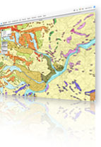
| MacMap®3.11 est arrivé ! |
La nouvelle version de MacMap® prend avantage de toute la puissance des processeurs Apple Silicon ARM64 M1, M2 et M3. Pour les utilisateurs c’est la promesse d’une vitesse d’exécution optimale sur les MAC les plus récents.
Nous en avons profité pour améliorer les externes Tableur et ceux du Pack Statistiques. La rapidité d’affichage et les temps de traitements ont fait l’objet de développements particuliers pour les rendre plus performants.
MacMap®3.11 reste compatible nativement avec les machines x86_64 Intel. Si vous êtes équipés avec ce matériel, pas besoin de le renouveler pour profiter de cette nouvelle version.
MacMap®3.11 est compatible depuis les systèmes MacOS 10.12 Sierra jusqu’à la toute dernière version Sonoma 14.2.
| MacMap® : une approche de la géographie à la carte. |
Utilisez MacMap® pour produire vos propres cartes ! Les qualités des ordinateurs d'Apple sont connues des cartographes, graphistes et dessinateurs. Avec MacMap®, adoptez la solution cartographique MacOs pour dessiner, visualiser et analyser.
Associez les possibilités des bases de données (requêtes, calculs, ...) à une visualisation immédiate sur une carte : c'est facile avec MacMap®!
MacMap® est un logiciel aussi efficace pour traiter des grandes problématiques publiques (démographie, transport, environnement, santé publique, culture et architecture du patrimoine, archéologie...) que privées (gestion de réseaux, calculs d'itinéraires, études d'impacts...).